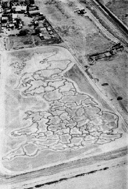
In 1976, Australian monkey trainer Alex Brackstone declared his four-hectare property northeast of Adelaide to be the independent Province of Bumbunga and named himself its governor-general. He was concerned that Australia was drifting toward republicanism and wanted to be sure that at least a part of the continent would always be loyal to the British Crown.
To underscore his devotion to the queen he drew a huge scale model of Great Britain using strawberry plants. He planned to sprinkle each county with authentic soil imported from Britain, but customs authorities put a stop to that, and the strawberries eventually died in a drought. Full points for effort, though.
Related: In her 1981 book The Emperor of the United States of America, Catherine Caufield says that British eccentric John Alington laid out a giant street map of London on the grounds of his estate at Letchworth, to rehearse his laborers who were traveling there to see the Great Exhibition. This article repeats the story, noting that Alington was greatly taken with giant maps: “In 1855, he had a reproduction of the fortifications of Sebastopol built so his workers could better understand the progress of the Crimean War. He also had a pond remodelled into a map of the world, which the men toured in rowboats as he lectured them in geography.” I haven’t been able to confirm this elsewhere, though.
